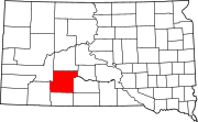
Long Valley, South Dakota
Appearance
Long Valley, South Dakota | |
|---|---|
 Looking north along Highway 73 | |
| Coordinates: 43°27′42″N 101°29′40″W / 43.46167°N 101.49444°W | |
| Country | United States |
| State | South Dakota |
| County | Jackson |
| Time zone | UTC-6 (Central (CST)) |
| • Summer (DST) | UTC-5 (CDT) |
| ZIP codes | 57547 |
| Area code | 605 |
Long Valley (also Longvalley) is an unincorporated community in Jackson County, South Dakota, United States.[1] Long Valley has been assigned the ZIP code of 57547.[2]
The town site is located in a long valley. It is a low basin valley that covers 21 miles (34 km) long by 6 miles (10 km) wide.[3]
Notes
[edit]- ^ "Long Valley, South Dakota". Geographic Names Information System. United States Geological Survey, United States Department of the Interior.
- ^ United States Postal Service (2012). "USPS - Look Up a ZIP Code". Retrieved February 15, 2012.
- ^ Federal Writers' Project (1940). South Dakota place-names, v.1-3. University of South Dakota. p. 48.


